Starting the road trip to the South Island meant actually getting from the North Island to the northern part of the South Island first. We drove from Opua (close to Paihia on the map below) to Wellington so we could catch the ferry to Picton on the South Island.
We could have made the drive straight from Opua to Wellington in a day, but decided to break it up by staying in Turangi overnight. Overall it is about 900 kilometers (560 miles) from Opua to Wellington. It might not seem like a lot of distance, but New Zealand's max speed limit is 100 km/per (62 miles/hr). Which might seem low, but all the roads, except around Auckland, are two lane and very curvy and hilly. It can be challenging to drive, especially learning with a right hand drive car on the left hand side of the road.
To save money, we decided that camping would be a good option as New Zealand is packed with amazing Holiday Camp Sites. Most camp sites are fully equipped with kitchens, toilets, hot showers and some have cabins that are bunk rooms or some similar to a motel rooms with kitchenettes. It is something that the United States should definitely follow. You do pay to camp, but it is worth it to have a place to cook(indoors) and have clean toilets and hot showers!

From Picton, we went west a little to the Marlborough Sounds, and then back east Blenheim, which is north of Kaikoura. From Blenheim, to Hanmer Springs (inland), to Christchurch, to Akaroa (coast of Christchurch), to Oamaru, to Dunedin, to Invergargill, to Te Anau, to Milford, to Queenstown, to Arrowtown, Wanaka, Franz Josef Glacier, to Greymouth, back to Picton. We had to miss the Nelson/Golden Bay area since we needed to get back to the North Island. Wish we could have seen more.

Wellington
We made it to Wellington and there happened to be a Chinese New Year celebration. Year of the Rooster. Geoff and Horatio both happen to be born the year of the Rooster!
Horatio and Geoff - Roosters!
Chinese New Year Festival night market. Lots of food carts.
We set up camp just north of Wellington in the town of Lower Hutt.
Big huge bouncy balloon for the kids to get their energy out
Windy Wellington. It happened to be blowing 50 mph that day!
Most folks thought it was a normal day!
Wellington Farmer's Market
Beautiful glass and art at the Te Papa National Museum
Some folks say Wellington is like San Francisco, very hilly.
View of the harbor from Mt. Victoria
St. Paul's - made of timber
Wellington Botanic Park
Geoff on the Interislander Ferry. The Ferry took 4 hours from Wellington to Picton.
For some reason, I have no photos of our landing in Picton or pictures of us in Blenheim at the Omaka Air Museum or of our trip to Hanmer Springs where they have hot spring pools. That was several days worth of great sites. Sigh...
Christchurch
The kids did the Adventure Park in Christchurch. Lots of climbing and zip lining.
We visited the Willowbank Wildlife Reserve. We got to see lots of animals, some native and local wildlife.
kangaroo and joey
emu
Kunekune Pig
peacock
Which animal is this one?
llama
kea
takahe
kiwi - dark photo since we could not take pictures with flash
picture found on the internet of a kiwi
We had heard to not visit Christchurch due to all the re-building/construction going on due to the past earthquake, 2011, destruction. We decided to visit anyway and really were taken by the pride and can-do attitude of the locals.
Eels in the Avon river
Internet picture before earthquake
After earthquake - Scoffolding around the church
Geoff and Horatio at the Tram high above Christchurch
view of Christchurch from Gondola base

Is 120km north of Dunedin on the Pacific Coast


We camped next door to the Steampunk playground in the harbor
Outside of the imposing free-standing stone building, a coin-operated "steampunk" engine greets visitors, complete with lights, engine and train while noises, and fire breathing out of its chimney. The building's exterior walls are decorated with creations such as giant flies made from metal and industrial parts.
Seal sunning in the harbor
A colony of little blue penguins lives in a disused quarry on the harbour not far from the historic precinct. The penguins established themselves in the early 1990s, once the rock quarry had been closed in the 1970s, and in 1992 a group of volunteers started to help make the area suitable as a breeding habitat for the penguins and provide guided tours. Apart from the success of the penguin colony, their efforts were rewarded with the colony receiving the Otago Regional Council's Environmental Award in 1995.
Dunedin
Dunedin was the largest New Zealand city by territorial land area until superseded by Auckland on the creation of the Auckland Council in November 2010. Dunedin is home to the University of Otago, New Zealand's first university (established 1869), and the Otago Polytechnic. Pictures of Dunedin from wikipedia as we did not have many good photos due to weather!

We toured the Cadbury chocolate factory. Lots of free chocolate!
Inside the railway station.
Horatio was asked by a Chinese tourist if she could take a photo with him
What are they pointing at??
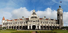
Front of Railway station
Picture of Railway station from wikipedia
Driving around Dunedin coast
Invergargill
Invercargill is the southernmost and westernmost city in New Zealand, and one of the southernmost cities in the world. It is the commercial centre of the Southland region. It lies in the heart of the wide expanse of the Southland Plains on the Oreti or New River some 18 km north of Bluff, which is the southernmost town in the South Island. It sits amid rich farmland that is bordered by large areas of conservation land and marine reserves, including Fiordland National Park covering the south-west corner of the South Island and the Catlins coastal region.
Many streets in the city, especially in the centre and main shopping district, are named after rivers in Great Britain, mainly Scotland. These include the main streets Dee and Tay, as well as those named after the Forth, Tyne, Esk, Don, Thames, Mersey, Ness, Yarrow, Spey and Eye rivers.


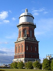
Water Tower and Civic Theatre in downtown Invercargill
Invercargill is also famous for the eHayes Hardware Store where they keep Burt Monro's Worlds's Fastest Indian motorcycle. Burt Munro is famous for setting an under-1,000 cc world record, at Bonneville Salt Flats in Utah, 26 August 1967. This record still stands; Munro was 68 and was riding a 47-year-old machine when he set his last record.
They have some very funny tools in the hardware store.
Special bolts
Interesting hammers
a Turbo Visor
Replica of Burt Munro's World's Fastest Indian
Horatio with the need for speed
Burt Munro's Offerings to the God of Speed.
All the parts used to make his motorcycle faster
Real World's Fastest Indian
Bluff
The most southern point of New Zealand (besides Stewart Island)
Te Anau to Milford Sound
The drive from Te Anau borders the Fiordland National Park. It is stunning!

Vast valley view
From valley to snow capped mountains
Milford Sound waterfall
calm waters in the Milford Sound
Kea - Alpine parrot - They like to eat rubber of all things.
So watch out for your doors, windows and windshield wipers.
Arrowtown
Arrowtown, 20 minutes from Queenstown, is a historic gold mining town in the Otago region of the South Island of New Zealand. Arrowtown is located on the banks of the Arrow River. Gold was
found in 1862 and it changed this small town to a Gold Mining town.
We stayed in Arrowtown as Queenstown was completely booked!

Arrowtown in 1905
Arrowtown 2017
A little bit of magic in downtown Arrowtown
Gold panning in the Arrow River
Maybe there will be some gold
Driving from Arrowtown to Queenstown
Queenstown
Queenstown sits on the shores of the South Island’s Lake Wakatipu, set against the dramatic Southern Alps. Renowned for adventure sports, it’s also a base for exploring the region’s vineyards and historic mining towns. There's bungee jumping off Kawarau Gorge Suspension Bridge and jet-boating on the Shotover and Dart rivers. In winter, there's skiing on the slopes of The Remarkables and Coronet Peak.
We did not participate in any of the adventure sports as they were quite expensive, but there was certainly a lot going on if you were inclined.

The Remarkables mountain and someone bungy jumping with Lake Wakatipu in the background - from wikipedia as there was not that much snow on the Remarkables when we were there.
View of Lake Wakatipu from the Gondola
Noah holding up the Leaning Tower of Wanaka
Puzzling World in Wanaka.
Great place with an outdoor maze. It was actually fun and challenging.
Public toilets!
Geoff inside the distoration room
Shotover River
jet boating on the Shotover river
too cold to take a swim!
On the way to Franz Joseph Glacier
Franz Joseph Glacier
The hike was wet and rainy, but we made it for this photo before it,of course, became sunny!
Waterfalls at Franz Joseph
Punakaki
Punakaiki is the gateway to the dramatic limestone country of the Paparoa National Park. It lies halfway between Greymouth and Westport on one of the most spectacular coastal highways in New Zealand. It's on the west coast just north of Greymouth.
The Pancake Rocks that Punakaiki is famous for, are limestone formations that began forming 30 million years ago, when lime-rich fragments of dead marine creatures were deposited on the seabed, then overlaid by weaker layers of soft mud and clay.
It was amazing to see the ocean splashing against these rocks.
Great view of rocks and waves


your tour pictures are astonishing and it attracts the tourist to visit this place. your tour also looks very adventurous. thanks for sharing it. it will give a lot of ideas to the tourist.
ReplyDelete